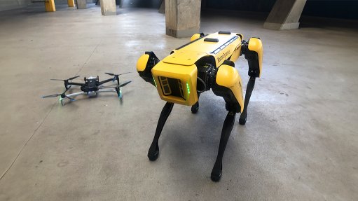
A Skydio drone and Boston Dynamics robot dog, just two of the tools at Dwyka's disposal
Photo by: Creamer Media
Mining technology company Dwyka Mining Services and its sister company Deep Tech have announced the launch of several new drone technology services through its partnerships with drone technology companies Wingtra, Emesent and now Skydio.
At a showcase event hosted at the FNB Stadium, in Gauteng, on June 20, Dwyka and Deep-Tech announced their newly signed strategic partnership and reseller agreement with Skydio, one of the largest AI-powered drone technology companies in the US.
This is the first time Skydio has penetrated the African market.
The Skydio drone technology is based on an onboard NVIDIA Jetson Orin graphics processing unit, which give the drones the capacity to see, understand and react to obstacles in real-time, making them just about impossible to crash.
This advanced spatial AI engine gives Skydio drones complete 360° awareness of their surroundings through the use of up to six custom navigation cameras that eliminate all blindspots. The drones can even operate in no-light environments.
These semi-autonomous drones are ideal for use in complex environments, automatically avoiding even the thinnest obstacles such as cables, so that collisions do not occur.
Also showcased at the event was the new light detection and ranging (LiDAR) payload on the vertical take-off and landing Wingtra drone, enabling the drone to carry out large-scale, highly detailed aerial mapping. With the Inertial Labs inertial measurement unit LiDAR payload and Hesai sensor, the Wingtra drone is capable of mapping up to 360 ha at a 90 m altitude.
Dwyka and Deep-Tech CEO Jamie van Schoor said the addition of the Wingtra LiDAR capability would complement the existing red green blue (RGB) range of photogrammetry cameras.
Meanwhile, Australia-based Emesent showcased use cases for its multicopter drone-mounted Hovermap LiDAR system in complex underground systems.
The Hovermap LiDAR system offers a sensing range of up to 300 m and more than a million points a second.
However, a novel application for Emesent’s Hovermap LiDAR scanner technology saw its installation on Spot, the semi-autonomous, highly agile robot dog from US-based robotics developer Boston Dynamics. With the device mounted on Spot, the robot is able to traverse pitch black mining tunnels safely and autonomously, delivering a clear and detailed map of the area upon its return.
Van Schoor noted the many use cases for these technologies in a variety of industries, from mining to energy to construction, pointing out how they improve safety.
However, he noted that without skilled technologists to operate and maintain these devices, they would be of little value.
“Humans are the most important thing in technology deployment. We spend a fortune in our business on making sure that our technologists are well trained, that they're very knowledgeable, and that they can support technology adoption across the space,” he said.